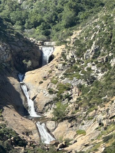
May 20 – Hike Three Sisters Falls near Julian
Three Sisters Falls near Julian
Saturday, May 20, 2023
10:00 AM at the 3-Sisters Trail Head on Boulder Creek Rd.
GPS: 32.984600, -116.677100
8:15 AM carpool meetup at Target Store lot, Escondido.
This is the year and time to visit Three Sisters Falls which has been running full due to the plentiful rains. This place has become a popular visit in recent years. A must-do before it gets hot in summer and is shut down.
WARNING: This hike is not for everyone but those in fair to good condition. Some people find this very difficult with the added warm to hot temperature resulting in $ costly helicopter rescues.
Overall, the hike is a moderate slope good trail with some rock step-ups at the bottom. 1.9 mile down to the falls and then 1.9 mi back up, an 800 ft change. We can take our time coming back up. Overall hike time is about 3.5 hours. Time to enjoy (watching) some swim in the pools or shoot the falls slide or explore a little. Dogs on leash are permitted. There are porta-potty’s at trailhead.
Its a 1.5 hour drive, 65 miles, to get there. 3 hrs drive time + 3.5 hrs hike time.
ETA back to Escondido, ? 4 PM.
Instructions: Eat a good breakfast and bring 2+ bottles of drinks in backpack, a light snack or lunch, camera, sun hat, hiking poles, etc… Bring/wear clothes/shoes that you can get wet in if you want to swim.
For Escondido area, Meet at Target store Escondido at Auto Park way and W.Valley Prkwy by Hwy 78, in the lot closer to the Starbucks store. Meet at 8:15 to carpool and get direction sheet or use your gps device. Need some willing drivers with good vehicles, let Vinnie know. There are 11 miles of narrow mountain roads with 5 miles of dirt roads. If you ride, then donate gas money like $10.
Other areas? Will need to work out a different route and rides.
Driving instructions: (Julian side), Follow Hwy 78/79 as to Julian. 1 mile before Julian turn right at Pine Hills Rd. Then 1.6 mile to Eagle Peak Rd. (easy to miss, odd split off). Then go 1.4 miles and left onto Boulder Creek Rd. Follow this winding road 8.6 miles to trailhead. Last 5 miles is dirt road. Trailhead may be over-crowded so find a place to park along road.
It’s very helpful to follow a gps tracker through all the little network of windy roads.
(Descanso side), I-8 to 79 north, exit onto Riverside Dr. Follow and get on Oak Grove Dr. Follow to Boulder Creek Rd. Then Boulder Creek up to trailhead.
Info contact: Text/Call Vinnie R. 858-231-7722. Let me know if you’re coming!
