
April 23 – San Marcos Mtn. Ridge Trail
WALK ALONG THE SAN MARCOS MTN RIDGE TRAIL (San Marcos)
SUNDAY, APRIL 23, 2:30 PM
MEET/PARK ALONG DOUBLE PEAK DR. BY RIDGELAND CT.
GPS: 33.11065, -117.18204
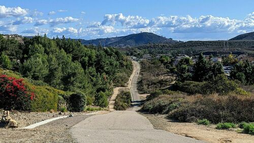
Come out for a good trail walk along the San Marcos area mountains, along the upper trail out to the communications tower and back. About 4+ miles and 2 hours, easy to walk the paved trail but with long hill inclines. This is NOT the trail from Discovery Lake to Double Peak. Our route will start from below Double Peak area going west to the communication tower and Lake San Marcos Cross then back. We will take a couple of optional deviations onto dirt trails through the bush and back out to main path. This trail has great views of the region in many places. After the walk, you can drive or walk up to Double Peak to look around from there. Bathroom is available up top at Double Peak parking. Dogs on leash and water is ok.
Bring a drink/water bottle and wear clothing for weather and sun.
Directions: Go to San Elijo Rd. as if you’re driving up to Double Peak top in San Marcos. But, we meet and park along Double Peak Dr. (before the peak) beyond the stop sign crossroad of Ridgeland Ct.
From Escondido area: Hwy 78 westbound, exit onto Twin Oaks Valley Rd then go south. Up the hill, the road changes name to San Elijo Rd. Follow downhill and look for Double Peak Dr on the right side and follow that as stated above to the parking area.
From Vista: From Hwy 78 take Melrose south to San Elijo Rd. Follow uphill to Double Peak Dr.
Or, southbound El Camino Real to east Palomar Airport Rd to southbound Melrose to San Elijo Rd eastwards.
From Hwy 5 north areas: Exit onto Palomar Airport Rd. eastwards to southbound Melrose to San Elijo Rd eastwards.
Or south areas: Leucadia Blvd. or La Costa Ave. eastwards to Rancho Santa Fe Rd. northwards to San Elijo Rd. eastwards.
Info Contact, Text/call: Vinnie Rodrig 858-231-7722.